
by Jeffrey Mount and Peter Moyle
Several years ago on this site, we celebrated the 20th anniversary of the Center for Watershed Sciences—what we termed a “really good idea.” That blog described the founding principles of the Center that live on today. A few years after starting the Center, we had a second really good idea—a course called Ecogeomorphology.
For us, the most rewarding aspect of the Center was the opportunity to collaborate with colleagues from different disciplines to try and address complex water management problems. We worked with very creative people willing to share their expertise toward some common goals. All while meeting our most basic standard—playing well with others. These collaborations with thought leaders in different disciplines and institutions — like Jay Lund, Richard Howitt, Ellen Hanak, Buzz Thompson, Brian Gray and others—was both fun and productive.
We asked ourselves a basic question: how do you capture this collaborative magic in the classroom and pass it along to students? We came up with Ecogeomorphology. This is the 20th anniversary of that second really good idea, and it started with an epic Alaskan river adventure.
The philosophy of the class was simple, but its logistics were very complex. We would recruit 12 students—usually four graduate students and eight undergraduates—from an array of disciplines. Every student was assigned to become an expert in something and then sharing that expertise with the other members in the class. We remember well some of the hysterically funny interactions between engineers and ecologists as they tried to find a common language and understand each other’s approach to problem solving. It was the same training we were getting in our research collaborations at the Center.
Once we had assembled a team and assigned expertise, we chose a big question that would be the theme of the class. We would study this question for 10 weeks followed by weeks of field study on a chosen river.
We are both field people at heart, so there had to be a lot data gathering in the field, a whole bunch of puzzling over problems while standing knee deep in a river, and some amount of adventure to lock in the learning. One of us (Jeff) had been running whitewater raft-based field trips in his home department for many years, simultaneously thrilling—and occasionally scaring—students while teaching them about rivers.
Fortunately for us, in the early years we had Dennis Johnson, the Director of Outdoor Adventures UC Davis. He bought into this idea of adventure education—indeed, he recommended most of the rivers we studied—and took care of all the complicated logistics. In later years, Jordy Margid took over for Dennis and carried on the tradition.
We also had the good fortune of funding. The costs of the course for the students were paid for by the Roy Shlemon Chair in Applied Geosciences (then held by Jeff) and the Presidential Chair in Undergraduate Education (co-held by Jeff and Peter). And, we had the Center as the home base to run the course.
Our first big trip in 2002 was an adventure. Peter raised a simple question. Alaskan rivers are highly productive when it comes to salmon, but why? They are very cold and turbid, so they don’t seem ideal for the growth of juveniles as they make their way to sea from their natal streams and lakes. And many juvenile fish—particularly sockeye and Chinook—travel many hundreds of miles in these cold, turbid, and presumably unproductive waters. We were heavily involved in the early research on the role of floodplains feeding native fish in the Central Valley. Where was the equivalent in these cold, glacier-fed Alaskan rivers?
We organized our class to ask Peter’s question. After extensive literature research, we headed to the Copper River watershed in Alaska to test some ideas through field observations. This trip set the benchmark for all others to follow.
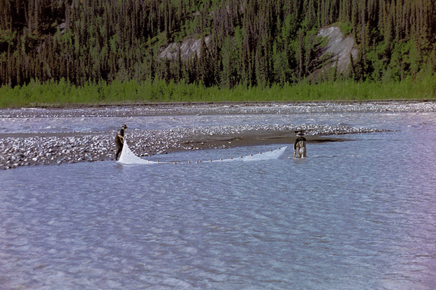
We started our trip at the base of the Kennicott Glacier. Water pouring out of the glacier was just above freezing, and such water behaves strangely due to its density and viscosity, especially with its high glacial silt load. But there was Peter with students in the water seining to see if there were any fish (there were none).

We moved down to the confluence between the Kennicott River and the Nizina River where the first inkling of an answer was revealed. It was a great learning experience for the students to watch their professors staring at this confluence with its giant cobble bars deposited by spring ice break up floods. After much head-scratching, the possible answer hit all of us simultaneously. There, throughout this cobble bar, were patches of clear, relatively warm water filling old scour channels. Water was flowing through the cobbles—decanting their silt load—and slowly emerging into these side channels where the water would warm before gently flowing back into the river. Algae in the water was being fed by willows and other plants sprouting along the edges. And all of this was feeding a food web, with juvenile salmon taking advantage of it. It was a warm, productive oasis in the middle of a raging, ice cold glacial river.

Clear, warm backwaters at the confluence of the Kennicott River and Nizina River fed by flow through the confluence bar, with abundant juvenile salmon taking advantage of the productive food web.
That discovery dictated the work of the next few weeks as we moved down the Nizina, to the Chitna River, then to the Copper River, and eventually into the Copper River Delta—a 270 mile adventure, while living out of whitewater rafts in some of the most spectacular, raw, and rugged scenery in North America. Our field studies confirmed this observation that backwater settings, wetlands connected to the river, and clear tributary creeks were crucial habitat for juvenile salmon.

Floating by massive glacial terraces on the Chitna River.
There were some memorable days. Along with daily, eye-popping discoveries, the students were exposed to the challenges of field work, where you hope Plan B works, because Plan A almost never does, and you better have a Plan C and D in mind. And we had suitably epic weather. We had hurricane force winds on one day that blew our rafts upstream despite more than 100,000 cfs passing beneath us. We had a mile-high loess dust storm roar up the canyon. We had the constant concern over ice-dam break outs (jökulhlaups) and the occasional grizzly bear. And epically, we experienced the anxiety-rich passage of our rafts beneath the face of Childs Glacier as it was actively calving into the river.

All of the students and the wonderful people who helped make this trip happen (especially Dennis Johnson, Deb Desrocher, Paul Butler, and Sarah Roeske) will never forget it. There is nothing like the joy of scientific discovery in a magnificent setting like Alaska’s Copper River: nature’s perfect classroom.
We took lessons learned from that first trip and built a terrific class. In subsequent years we went to the Skeena River in British Columbia to record how habitat complexity in a river drives biodiversity. We went to the Green River below Flaming Gorge Dam to document how river ecosystems recover with distance downstream of a dam. We made several trips down the Colorado River in the Grand Canyon to evaluate efforts underway to improve physical habitat. We often used the Wild and Scenic stretch of the Tuolumne River and its main tributary, the Clavey River, as a study site to compare dammed and undammed rivers. The 2009 Tuolumne class spearheaded the creation of the short book Confluence: A Natural and Human History of the Tuolumne River Watershed, which has been used in multiple classes since. And on the Kobuk River in Alaska, we studied how changing climate is altering the ecology and geomorphology of rivers north of the Arctic Circle, while wolves howled and yipped in the background (this was our new definition of a howling success).
In all the years we ran this course, we brought all the students back in reasonably good condition, with no major injuries. This is a credit to our handlers, Dennis Johnson and Jordy Margid, who built a culture of safety. Our only significant injury was to Peter, who ironically hit his head on the first aid kit and got a helicopter ride out of the Grand Canyon.
This class was a really good idea, and we are both proud of the effort. Mostly we feel very lucky that that we had the opportunity to conduct this grand experiment in mixing adventure and education. And we are especially pleased with the product of the class: the students. Most students who took this course over the years have gone on to successful careers in resource management, usually involving water and rivers.
Finally, it is very satisfying to see that the course lives on, 20 years and counting. Today Nicholas Pinter and Sarah Yarnell are rounding up students, teaching them how to collaborate, and taking them into the field for new, inspiring experiences. Like many college field classes however, funding for these inspirational and life-changing classes is difficult to come by. They rely almost exclusively on private donations and fundraising. You can help support the continuation of Ecogeomorphology here.
Jeff and Peter

2002 Copper River Trip participants:
Jeff Mount, Instructor
Peter Moyle, Instructor
Sarah Roeske, Instructor
Sarah Yarnell, Teaching Assistant
Angela Depaoli, Undergraduate student
Carson Jeffres, Undergraduate student
Chris Hammersmark, Graduate student
Dylan Ahearn, Graduate student
Joe Wheaton, Undergraduate student
Joel Passovoy, Undergraduate student
John Wooster, Graduate student
Kaylene Keller, Graduate student
Kristen Morgan, Undergraduate student
Martin Koenig, Undergraduate student
Mark Rains, Graduate student
Randy Bowersox, Graduate student
Steve Winter, Graduate student
Wendy Trowbridge, Graduate student
Dennis Johnson, Trip Leader
Debbie Desrochers, Guide
Paul Butler, Guide

Instructors, students, and guides in the 2002 Copper River Ecogeomorphology class.
Leave a Reply