

By Alex Rabidoux, Max Stevenson, Peter B. Moyle, Mackenzie C. Miner, Lauren G. Hitt, Dennis E. Cocherell, Nann A. Fangue, and Andrew L. Rypel
Putah Creek is a small stream located in the Central Valley that has been extensively modified to suit urban and agricultural water needs. Following ratification of the Putah Creek Accord in 2000, however, the creek has also been proactively managed for restoration of native fishes, including fall-run Chinook salmon. The Accord stipulates that pulse flows be supplied to the lower creek during fall and spring to mimic a natural flow regime. A result from these environmental flows has been salmon spawning in the creek since 2003 (Yolo Bypass Wildlife Area Land Management Plan, 2008). Unfortunately, the future of Putah Creek salmon is not yet secure.
In November 2021, salmon entering Putah Creek were part of a large fish kill in the lower creek. The event took everyone familiar with the creek by surprise and prevented successful migration of the creek’s fall salmon. Only 4 or 5 adult Chinook salmon made it upstream to suitable spawning habitat. The result was particularly tragic as it followed on the heels of the restoration of a salmon run in the creek, as well as habitat for other fishes. Salmon spawning in the creek has produced 10s of thousands of out-migrating juveniles. The return of salmon is an important, highly visible symbol for why Putah Creek is often regarded as a role model for effective water management and environmental stewardship (Davis Enterprise, 5/24/2020).
In this blog, we describe the conditions that led to the fish kill in lower Putah Creek and the response to the kill by scientists and others monitoring the creek. Although the kill was a disaster for salmon and other fishes in the creek, it also demonstrated how representatives of diverse agencies could work together, without finger pointing, to find out what happened in order to prevent it from happening again. The response showed how the Putah Creek Accord is still working. The authors of this blog combined their collective experiences to conduct an autopsy, and in doing so, paint a detailed picture here of what happened.
Salmon in the creek
The fall of 2021 started well for the creek, as the creek was prepared to receive its annual salmon run. In early October, the Solano County Water Agency (SCWA) and soon to retire Putah Creek Streamkeeper, Rich Marovich, celebrated the removal of a longstanding low dam that caused formation of undesirable habitat upstream in what might otherwise have been spawning grounds for salmon. After years of failed negotiation and lack of regulatory enforcement, a unique relationship was formed with the help of UC Davis’s Dr. Peter Moyle, Water Audit, and SCWA that resulted in removal of the debris dam in the cool-water region of Putah Creek (Figure 1). This allowed for subsequent restoration activity to revitalize the stream bed in the area for salmon spawning. Similar restoration activities have been performed throughout the creek since 2016.


In early October, UC Davis researchers were gearing up for the annual sampling of fall-run Chinook salmon carcasses in the creek. As part of this effort, crews from UC Davis and SCWA canoed and inspected all 26-miles of Lower Putah Creek. The survey examined possible impediments to fish passage that could prevent upstream movement of adult salmon. This routine sampling has been in place since 2016 and salmon have been observed returning to spawn successfully in Putah Creek every year over this time frame.
The success of spawning is most evident in the spring when their juvenile salmon (smolts) begin out-migrating in droves, headed for the ocean. In 2018, over 30,000 juvenile salmon were captured and released from a rotary screw trap, highlighting the productive capacity and potential of the system. Researchers and agency staff alike had high expectations that 2021 would bring another large return of salmon. 2021 might also mark one of the first years in which natal-origin Putah Creek salmon (some of those 30,000 juveniles from 2018) could return to spawn in Putah Creek. With salmon populations struggling throughout the Central Valley, Putah Creek represents one of few locations where numbers are on the rise (California Water Blog, 5/13/2018).
In the months leading up to the annual adult salmon migration, SCWA worked closely with a multitude of regional partners including the Putah Creek Council, UC Davis, California Department of Fish & Wildlife (CDFW), and Los Rios Farms on timing of fall pulse flows and removal of the check dam at the base of the creek. The fall pulse flows have the intended purpose of attracting salmon to Putah Creek, but timing of the pulse is a balancing act of salmon migration patterns, flooding of waterfowl habitat, mosquito risks and water availability in the Yolo Bypass. Therefore, after close coordination with the regional partners, the fall pulse flow was scheduled to begin on November 2.
Atmospheric river rain event
On October 24, one-week before the scheduled pulse flow, a large atmospheric river event dropped 6-8 inches of rain on the Putah Creek and Cache Creek watersheds. The event was atypically early, providing 25-30% of the region’s annual average rainfall in just 24 hours. The large rainfall, in conjunction with the burn scar from the 2020 LNU Fire (which burnt over 90% of the Interdam Reach of Putah Creek), prevented most of the rainwater from soaking into the ground, and instead inundated Putah Creek with nutrient rich runoff. The rain event was so large, >1,500-cfs of creek water was released through the Putah Creek Diversion Dam for several hours during evening and early morning hours after the storm event. While the event was a natural pulse flow for salmon, several fish passage barriers were still in place, preventing salmon from migrating into Putah Creek on the coattails of the rain-driven pulse. These barriers include an earthen road crossing (Rd 106A, Figure 2, left picture) and an agricultural impoundment dam (the Los Rios check dam, Figure 2, middle and right pictures). In a typical year, both structures are removed to permit upstream passage of adult salmon and timed to coincide with the pulse flow.


The fish kill
Following the storm, on November 1, the two remaining fish passage barriers, the road 106A crossing and the Los Rios check dam, were removed. At Los Rios Check Dam, several salmon were observed swimming upstream after the flashboards were removed. Presumably, salmon had moved up the Toe Drain and into the very lowest reaches of Putah Creek following the pulse from the storm. SCWA’s consulting wildlife biologist, Ken Davis, noticed a total of 6 moribund salmon, a prelude of what was to come.


On November 2, the scheduled salmon attraction flows began (November 3rd through the 8th ). At that time, UC Davis researchers observed a large-scale fish kill in Putah Creek near the Los Rios check dam. The kill included not only salmon, but Sacramento sucker, a variety of sunfishes, striped bass, largemouth bass, common carp, and mosquitofish; these fishes represented a wide range of sizes and diverse ecological niches. All dead fish were found within one mile of the check dam.
During the field investigation, UC Davis researchers observed black, nutrient-rich water, entering Putah Creek just upstream of the Los Rios check dam. The researchers then noted that water with low dissolved oxygen (DO) concentrations was being pumped from the Toe Drain into the CDFW Wildlife Refuge. They also noted and that water draining from the refuge ponds was re-entering Putah Creek, causing a DO sag near the check dam. UC Davis researchers notified SCWA, CDFW, and DWR of their findings, and asphyxiation was noted as the cause of death of fish in Lower Putah Creek.
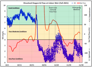
Despite being tolerant of low oxygen for short periods of time, adult Chinook salmon are very large fish, which have greater oxygen requirements than smaller fish, so adult salmon were likely among the first individuals to perish. But also killed, were much smaller fish, such as sunfish and mosquitofish, which are more capable of surviving low-oxygen conditions. Unfortunately, dissolved oxygen concentrations as low as 1-2 mg/L were reported in the Toe Drain, the typical threshold for sufficiently oxygenated water for salmon is approximately 7mg/L. The sag in dissolved oxygen observed in late October through early November is the largest dissolved oxygen dip recorded in the past several years. All female salmon examined perished before spawning, as indicated by presence of fully-developed eggs still in their ovaries (Figure 3).
Aftermath


UC Davis researchers continued to conduct weekly surveys of Putah Creek through January, to monitor any upstream movement of salmon. Based upon their initial findings, SCWA began to work closely with the CDFW Wildlife Refuge to identify specific fields and drains impacting Putah Creek. In short order, CDFW and their operating partners from Los Rios Farms, were able to eliminate any further tailwater leakage into Putah Creek by modifying a single culvert. SCWA staff then began periodic water quality sampling of lower Putah Creek within the Yolo Bypass, as well as the confluence with the Toe Drain. Water quality sampling was extended to encompass over 17-miles of the Toe Drain from northern Liberty Island in the Delta, down to the Sacramento Weir just north of Interstate 80. Results of sampling, as well as data from the Department of Water Resources’ (DWR) real-time water quality stations, showed over 13-miles of water with critically low DO in the Toe Drain both upstream and downstream of the Putah Creek confluence. SCWA staff quickly realized that the DO issue and corresponding fish-kill were far beyond the capability of SCWA to monitor alone. And Putah Creek alone was not the only part of the system at risk. Additional partners and creative solutions would be needed to resolve extent and cause of the poor water quality.
On December 8, 2021, reports from UC Davis and SCWA were shared with key stakeholders in the Yolo Bypass, including DWR, CDFW, State Water Contractors, Reclamation District (RD) 108, and the Northern California Water Association. In subsequent discussions with RD 108 and DWR, there appeared to be a novel capacity to convey either agricultural drainage water from the Colusa Basin Drain or Sacramento River water from the Knights Landing Outfall Gates to potentially flush the Yolo Bypass Toe Drain and push out remaining low DO water in favor of replenishing it with less affected water.


Based on water quality and fish concerns by CDFW and DWR staff, SCWA staff removed debris that had accumulated north of the I-80 in the Yolo Bypass to further facilitate fish passage and water conveyance. SCWA also continued water quality monitoring in the Colusa Basin Drain. One week later the region again received a series of atmospheric storm events that subsequently flushed the Toe Drain and restored DO to more suitable levels. Unfortunately, the low DO conditions had persisted for too long, and no additional salmon were observed migrating into Putah Creek. In total, UC Davis researchers identified 81 Chinook salmon carcasses within the last 2.25 kilometers of Lower Putah Creek, and 1 live salmon in the upstream reaches of Putah Creek, although a few (4-5) additional salmon apparently made it up to the Diversion Dam (observations of staff). Recent snorkeling surveys below diversion dam detected juvenile salmon, indicating successful spawning by the survivors of the fish kill (T. Salamunovich, April 2022).
Lessons learned
While the event was tragic, it provided several key lessons for the Lower Putah Creek and Yolo Bypass community:
- Organic matter and low DO are on-going problems. Initial findings by the USGS (Stumpner, 12/15/2021) and others, indicate that the large DO sag in the Toe Drain and associated parts of the Delta was largely due to a rapid increase in flow (precipitation and run off) following the large rain event at the end of October. This flow pushed out accumulated organic matter in the creek and ditches, presumably from deposition of dead aquatic vegetation. In the Yolo Bypass, the Toe Drain, and related water conveyance canals, invasive aquatic vegetation is pervasive. The last 2-miles of Putah Creek (within the Yolo Bypass and DFW Wildlife Refuge) also support an abundance of aquatic vegetation throughout the main channel. When widespread in such quantities, decaying aquatic vegetation can lead to diminished dissolved oxygen concentrations.
- Climate change requires building more resilent systems. Large atypical storms, such as the one that occurred on October 24 may become more common, and will require planning outside of previous bounds of environmental variability, in order to build management systems capable of adapting to changing conditions quickly.
- Regional partnerships are increasingly important. The event emphasized the importance of regional partners, including resource agencies (CDFW, DWR), local public agencies (SCWA, RD 108), scientific experts (UC Davis), and local landowners. Most of the lands in Yolo Bypass and along lower Putah Creek watershed are privately owned, so cooperation among landowners is truly essential.
- Scientific support is essential. Ongoing long-term research conducted by UC Davis continues to provide pivotal and timely data helping to protect and restore Putah Creek. Without the observations of UC Davis scientists in November, the Water Agency and other stakeholders would not have been aware of the magnitude and causation of the fish kill on Putah Creek, until much later. Scientists are also collaborating directly with managers in near real time to improve conservation; thus Putah Creek represents a critical example of real time resource management in California and the Delta.
- Fish passage barriers need to be modified or removed. Modification of existing fish passage barriers in Putah Creek and in the Yolo Bypass, including the Road 106A Crossing, Los Rios Check Dam and the Lisbon Weir, should be high priority for resource agencies. DWR and CDFW oversee most of these facilities.
Alex Rabidoux is a Principal Water Resources Engineer with Solano County Water Agency. Max Stevenson is a Streamkeeper with Solano County Water Agency. Peter B. Moyle is a Distinguished Professor Emeritus at the University of California, Davis and is Associate Director of the Center for Watershed Sciences. Mackenzie C. Miner is a MS student at the University of California, Davis. Lauren G. Hitt is a PhD student at the University of California, Davis. Dennis E. Cocherell is a Lab Manager and Staff Research Associate in Wildlife, Fish, and Conservation Biology at the University of California, Davis. Nann Fangue is a professor and Chair of the Department of Wildlife, Fish & Conservation Biology at University of California, Davis. Andrew L. Rypel is a professor of Wildlife, Fish, and Conservation Biology and Co-Director of the Center for Watershed Sciences at the University of California, Davis.
Further Reading:
USGS (unpublished). Stumpner, Elizabeth. BGC UPDATE: Low Dissolved Oxygen and High Nitrate Following Storm Events
Chapman, E., E. Jacinto, and P. Moyle. Habitat restoration for Chinook salmon in Putah Creek: a success story. https://californiawaterblog.com/2018/05/13/habitat-restoration-for-chinook-salmon-in-putah-creek-a-success-story/
Kiernan, J.D., P.B. Moyle, and P.K. Crain. 2012. Restoring native fish assemblages to a regulated California stream using the natural flow regime concept. Ecological Applications 22: 1472-1482.
Marchetti, M.P., and P.B. Moyle. 1995. The case of Putah Creek: conflicting values complicate stream protection. California Agriculture 49: 73-78.
McManus, J. 2022. It’s time to restore habitat for salmon runs, before it’s too late. CalMatters https://calmatters.org/commentary/2022/03/its-time-to-restore-habitat-for-salmon-runs-before-its-too-late/
U.S. Geological Survey, 2022. USGS water data for the Nation: U.S. Geological Survey National Water Information System database, accessed November 17, 2021 http://dx.doi.org/10.5066/F7P55KJN
Willmes, M., E.E. Jacinto, L.S. Lewis, R.A. Fichman, Z. Bess, G.P. Singer, A. Steel, P.B. Moyle, A.L. Rypel, N.A. Fangue, J.J.G. Glessner, J.A. Hobbs, and E.D. Chapman. 2021. Geochemical tools identify the origins of Chinook Salmon returning to a restored creek. Fisheries 46: 22-32.
Willmes, A. Steel, L. Lewis, P.B. Moyle, and A.L. Rypel. 2020. New insights into Putah Creek salmon. https://californiawaterblog.com/2020/10/18/new-insights-into-putah-creek-salmon/


Tesla one way valve makes a great fish dam bypass — Check it out.
Any word on removal of the extensive beaver dam approx 100 tds upstream fron the lowest check dam? It was present in March 2022.
want more resilient systems and protection for salmon? Check the abundant science and field reports and use beaver dam analogs or -gasp- allow beaver to do their work.
Of course dumping of toxic fluids is hard to overcome even for our very efficient beaver engineers
Effective long-term stream restoration will require adaptable local institutions with regular funding to both assess conditions and respond in timely and effective ways. Putah Creek is a great story of restoration success, and this tragic episode shows both the need and potential for responsive local environmental management institutions.